Marine - Environmental Optics Laboratories & Remote Sensing Center

FIND Project Imgery, Fluid Mud Movement & SONDES

Home
Fluid Mud Flux SONDES
SEBASTIAN FIND Project Imgery, Fluid Mud Movement SONDES - How they work
Indian River Lagoon & Near Coastal Water Images & Hyperspectral Signatures: Methods - Instruments
About Us
View Our Brochure
Our Services
Projects
Location
Contact Information
Meet Our Staff
Current Research Info & Airborne Remote Sensing Images - BP Oil Spill Images
Research Summaries
International Society for Optical Engineering (SPIE) Publications
Papers
Hyperspectral Image Fusion with Aerial Photography

Airborne Imagery & In-situ Optical and Acoustic Data/Imagery

Atmosphere Conditions 1/30/2015 - Wind SW 3 Knts.
webassets/Jan302015Satelliteimagery.jpg
Courtesy NASA (MODIS) & NOAA (GOES) Satellite Imagery
webassets/WarningRestrictedAirspaceFINDAREA.jpg
FAA Warning & Airspace Restrictions At Dredge Site & Region

Images

webassets/bostater000061718.jpg
Download PDF Below

FIND DMMA Aerial Multispectral Image 1/30/2015

webassets/00005Capture181928.jpg
Download PDF Below

FIND Wabasso Area Intracoastal Waterway Dredge Operations 1/30/2015

webassets/bostater000051909Capture.jpg
Download Image Below

FIND Wabasso Area Intracoastal Waterway& Islands Dredge Operations 1/30/2015

In-Situ Transport/Flux Data from Sondes (Probes) & Optical Data

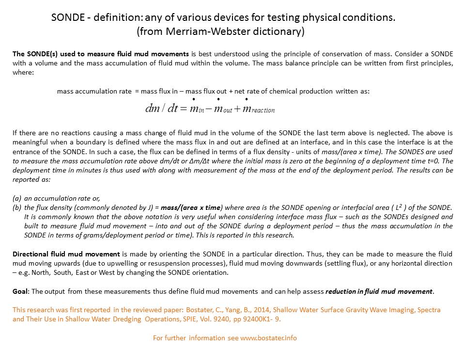
In-Situ Sondes collect the horizontal movement in specified directions (North, South, East, West) and vertical In-Situ Sondes collect the upwelling and settling of water column particulate motion.

These specially designed Sondes produce movement of fluid mud and dense particle movements in a maximum of 6 directions. The resulting data are reported in terms of the mass movement or motion  (mass/unit area/time - kg/meter2/day) of the dense nephelometry layer at or near the water bottom in aquatic habitats.

Horizontal motion measurements in Indian River Lagoon areas suggest the equivalent of a 10 lb bag of flour of fluid mud horizontally moving per meter2 in a day - or well over a ton of fluid mud moving per year per meter2.

Obviously, this fluid mud blocks light from reaching the bottom of the water column where aquatic vegetation and other organisms use the light for growth and to support living functions such as "seeing their food".


webassets/FluxPhotosPPT.jpg

Click here to see the fluid mud collected by a Sonde

webassets/FluidMud.jpg
webassets/SONDES.jpg

The sondes are deployed using rods and are capped before and after deployment to insure no material enters the turbulent dissipation chamber during the deployment or retrieval process. The sondes do not measure gross sedimentation, gross or net movement - they measure the mass flux density of particulates moving within the bottom boundary layer or "lutocline".

Dr. Charles Bostater
321-258-9134