|
2. Low Altitude Hyperspectral Image &
Spectral Signatures of SAV at Sebastian Inlet, IRL Note Influence of water waves on ~1
meter GSD pixels.
> Click here to download Airborne SAV Hyperspectral Signatures
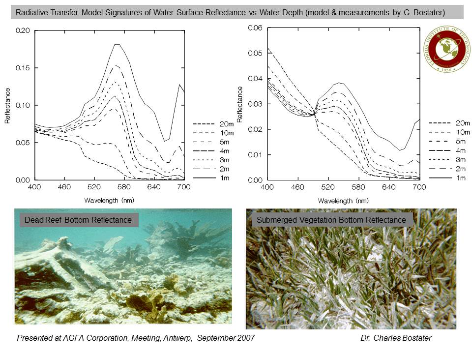
3. Modeled Low Altitude Hyperspectral Signatures
of SAV and Coral Bottom with Changing Water Depths.
> Modeled Hyperspectral Signatures in Shallow Waters (click to download)
4 .
Low Altitude Hyperspectral and Digital Multispectral Image of Indian River Lagoon, Florida.
> Airborne Hyperpsectral & Multispectral Image of Coastal Inlet (click to download)
5. Example
Simulated Water Wave Filed Using Spectral Wave Models For Shallow Waters Research needed to understand influence of Water Waves on Retrieving Water Quality Information
> Simulated Water Surface Wave Field (click to download file)
6. Sebastian Inlet,
Florida Hyperspectral Image demonstrating the ability to scale the water surface wave field in airborne imagery Research concerning wave field characteristics on water surface reflectance for SAV and Water quality detection.
> Wave field scale image (click to downoad)
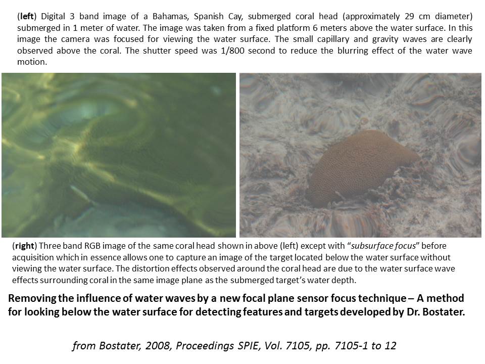
7. Demonstration
of a method to remove the influence of water surface waves for subsurface feature and object detection.
> Demonstration of a method to remove the water surface waves for subsurface detection (click to download)
8. Banana River
shoreline monitoring from small vessels using multispsectral and hyperspectral imagers. > Demonstration of image data fusion optimaztion for feature and target detection on or nearby shorelines
and littoral zones.
Shoreline monitoring using advanced imaging systems (click to download)
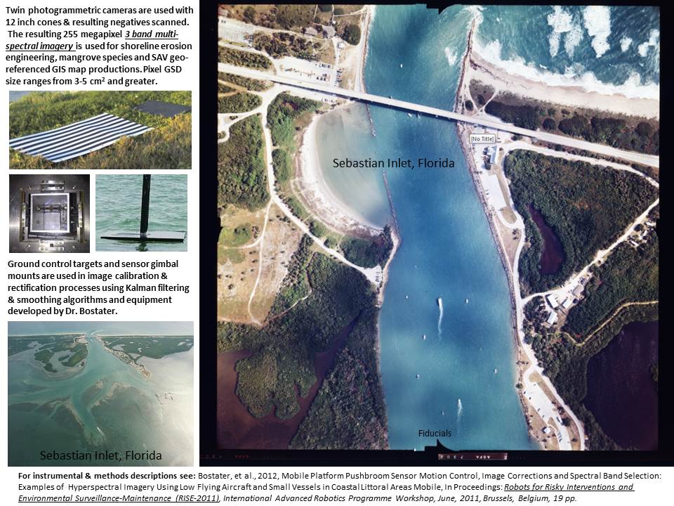
9. Sebastian Inlet,
Florida - multispectral 255 megapixel airborne imagery, ground targets and camera mount. > Example vertical photogrammetric digital multispectral image and ground control targets for engineering
and mapping applications.
Sebastian Inlet MS image example (click to download)
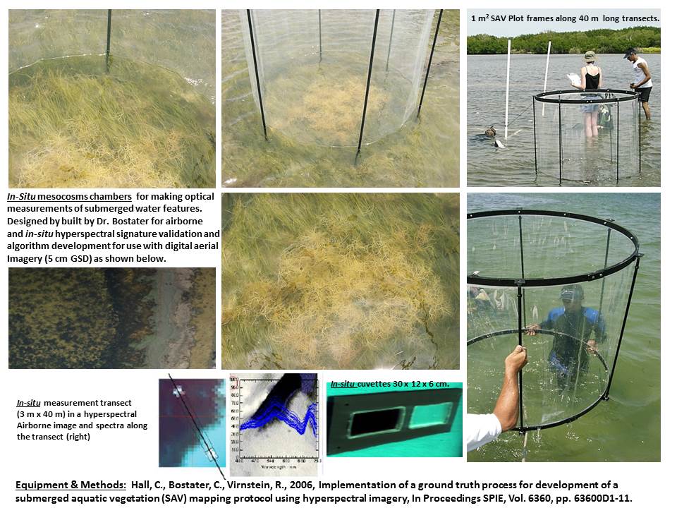
10. In-situ
mesocosms and cuvettes in Indian River Lagoon - instruments and methods for airborne SAV mapping > Example ground validation methods and instruments.
Image of cuvettes (click here to download file)
11. Instrument:
Buoy Instrumented for Spectral Measurement of Water Quality - NASA Tech Briefs Summary > NASA Innovative Technology Award was earned for this project.
Instruments: Water Quality Real Time Buoy: (click here to download file)
12. Airborne Instruments
- Metadata Descriptions & Examples > Spectra
and image showing High Chlorophyll Biomass in northern Indian River Lagoon waters.
Metadata Description of Instruments & Example Spectra & Image (click here to download file)
13. Airborne Pushbroom
Imagery Correction Techniques- Equipment Overview > Schematic
showing instrument signal Kalman Filter & Smoothing techniques.
Schematic of Kalman Image Correction Technques Developed (click here to download file)
14. Airborne Multisensor Systems
- airborne systems schematic - IMU, GPS, Film, HSI, HD Viseo, Nikon D2Sx, FODIS > Schematic showing example of airborne instruments used.
Multi Sensor Equipment Schematic (click here to download file)
15. Digital Multispectral Airborne Photogrammetric
Image (~255 megapixel) over Eau Gallie Causeway, Central Indian River Lagoon, Florida. > Indian River Lagoon: example of airborne MS photography.
Eau Gallie MS image snapshot (click here to download file)
16. Hyperspectral Imaging Equipment: System Design
description for Pushbroom imager built by Dr. Bostater. > Computer Screenshot and Equipment Systems Design.
Pushbroom Imager Instrument Design (click here to download file)
Geophysical Science & Engineering Publication Images
17. Geophysical Science & Engineering Imaging
& Modeling - Space Coast US
Click to download published research
Dr. Charles Bostater
321-258-9134
|
